I came across a number of maps showing Arctic ice extend from 1893 to 1961 collected by DMI in “Nautisk Meteorologisk Aarbog”. Each year DMI have collected information on sea ice extend so that normally each of the months April, May, June, July and August ice extend was published.
There is much more to be said about these, but this is my summary for now.
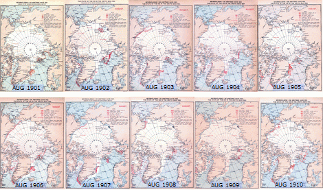
Fig 1. 1901-1910 Arctic sea ice data collected by DMI. Click to enlarge!
Sadly, just for a few years we also have March or September available, and thus we normally can’t read the Arctic ice minimum (medio September) from these maps. The August trends will have the main focus in this writing.
First of all I would like to thank “Brunnur” in Iceland for making these maps available on the net beautifully scanned. This is a gold mine and I’m sure you know this, Brunnur.
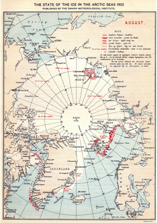
Fig 2. August 1902.
The August data in the beginning of the century normally resembles December ice area for recent years. Year after year in the period 1901-1920 we see pretty much same picture. The sea east of the Russian island Novaja Zemlja is often frozen over even in August, and there is still sea ice between Baffin Island and Greenland.
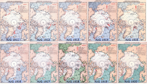
Fig 3. 1911-1920. Click to enlarge!
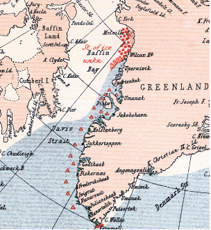
Fig 4. August, 1916. The December-like August ice area continues to be observed year after year, and in 1916 most of the ocean between Baffin Island and Greenland is ice filled (- even in August!).
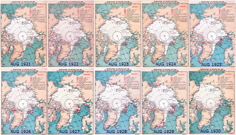
Fig 5. 1921-30
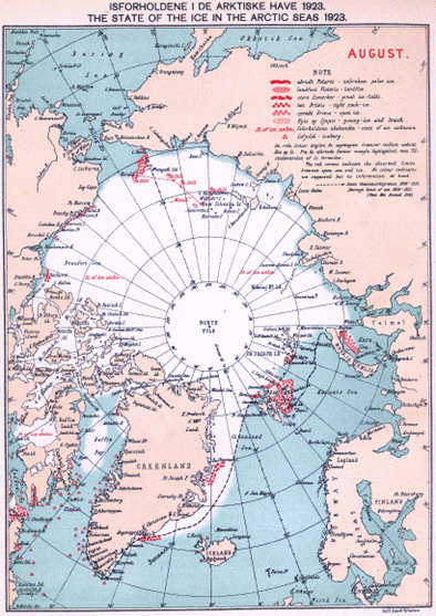
Fig 6.
Finally in 1923 something new happens: The ice east of Svalbard and east of Novaja Zemlja is on retreat.
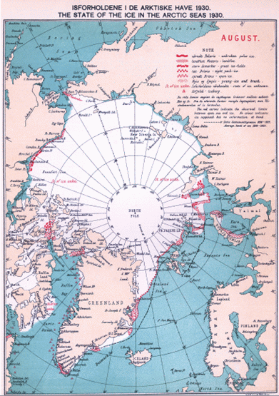
Fig 7.
In 1930, the retreat has gone even further: Svalbard Is ice free, and ice free waters have been observed far east of Novaja Zemlja. In addition, the Baffin bay is now almost ice free. Puzzling is, that the ice extends on the pacific side of the Arctic remains rather constant in all these years.
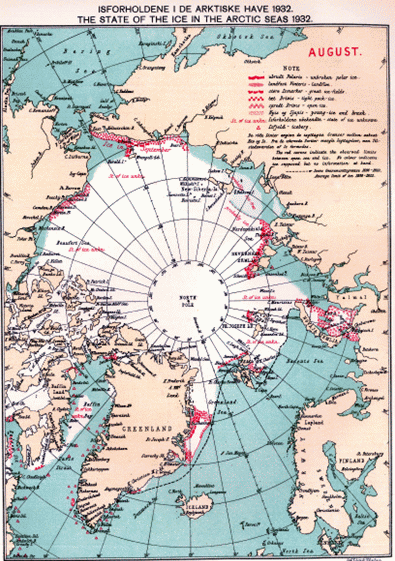
Fig 8.
In 1932 we see in August open ice almost all along the Russian shore. So even though we do not see the September ice minimum here, we almost have an open NE passage.
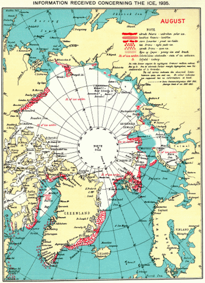
Fig 9.
After a rather icy 1934, then 1935 again in August shows an almost open NE passage and in 1935 open waters are observed not that far from the North pole.
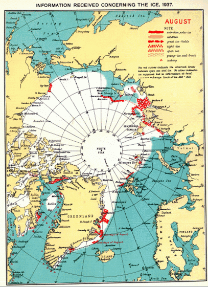
Fig 10.
In 1937, more open waters are observed in the Pacific and East Siberian areas.
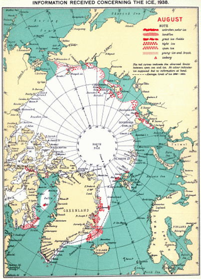
Fig 11.
1938: Unprecedented areas of open waters.
(And again, this is not the ice minimum but just the August ice area)
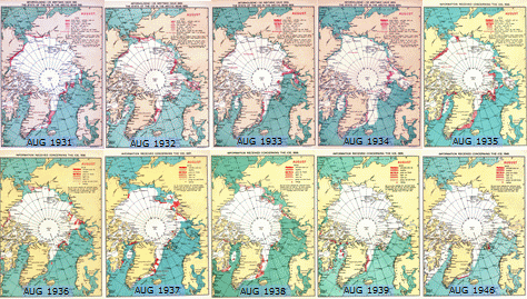
Fig 12. 1931-1946
Already the year after, 1939, the ice extend resembles the pre 1923 extend.
We see that a decline in Arctic ice area from around 1921 ends possibly in 1938.

Fig 13. 1947-1956
Sadly we don’t have the Arctic warm years 1940-45, but just the colder years 1946-56.

Fig 14.
In 1952, The August sea ice area once again appears like the 1900-1920 extend. If Arctic ice areas reflects temperature well, then years around 1946-54 should be as cold as before 1923. It appears that the ice cover from 1938 to 1946 has recovered quickly.
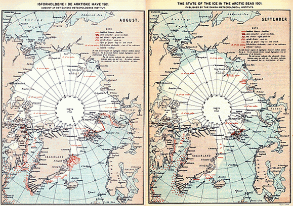
Fig 15.
Here is an August–September comparison for 1901. For most of the Siberian shores in September we see open waters as far back as 1901.
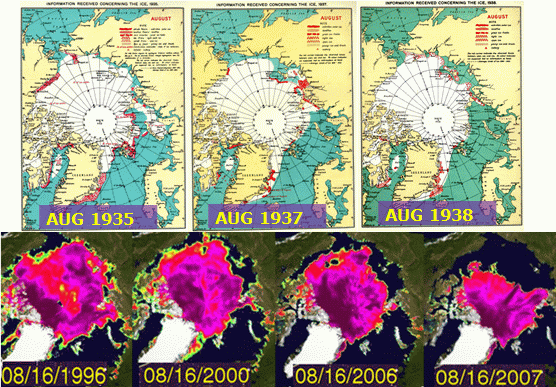
Fig 16.
Some warm Arctic years in the 1930´ies from DMI compared to recent Chryosphere today August graphics.
It seems that ice area for 1935 and 1996 were roughly similar (and it seems that ice area for 1938 and 2000 were roughly similar etc.):
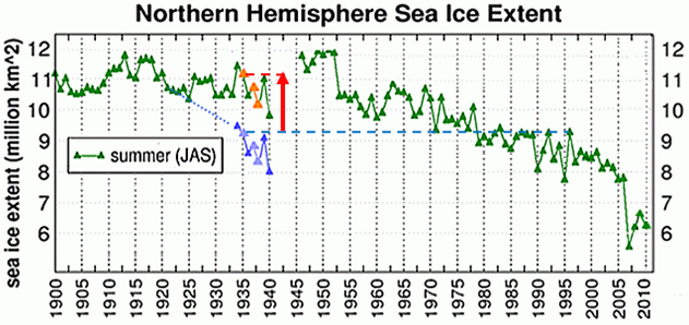
Fig 17.
However, Chryosphere Today do not show 1935 ice area similar to 1996. Instead Chryosphere has added roughly 1,9 mio km2 to the ice area 1935 compared to 1996 (- The size of Greenland is 2,1 mio km2… ).
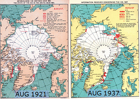
Fig 18a. We can also illustrate the missing Chryosphere ice decline after 1921 in another way.
The Chryosphere Arctic ice area data actually suggests a little more ice in 1937 than 1921 – but as shown above DMI, suggests a strong decline after 1921.
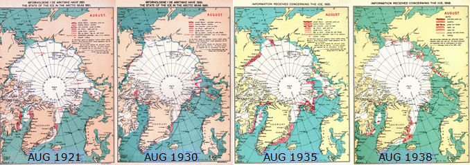
Fig 18b – and here the ice decline 1921-38 in four stages.
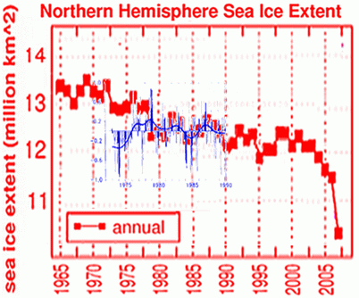
Fig 19. Also in another context it appears that the ice area data on Chryosphere has added area to older data:
If we compare the Chryosphere annual sea ice extend with the IPCC SAR 1996 data, we can see that the dive in 1996 data before 1979 is not represented in Chryosphere data. The divergence is perhaps 0,9 mio km2 over just the period 1973-1979.
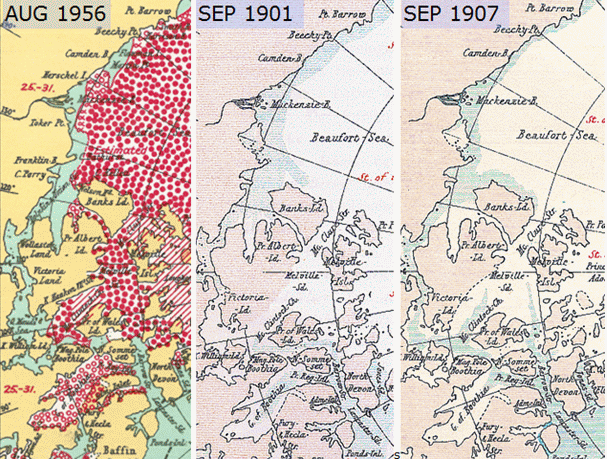
Fig. 20, NW Passage in DMI data.
In September 1901 we are not far from having open NW passage and in September 1907 we do have an open NW Passage. We don’t have September images later than 1907 to determine if the NW passage is open.
What have we learned according to DMI´s international compilation of sea ice data?
– That sea ice data has declined strongly even in the recent past before human CO2 outlet.
– That Sea ice from a level not far from the 2006 level has recovered very fast 1938-1946.
– That the Sea ice decline documented year after year in DMI maps after 1921 apparently is not shown in Chryosphere data for some reason.
We do not have the WW2 data, but the maps of 1957-61 ice areas EXIST!
These are the years where we had a strong Solar max and photos of US Navy submarine on a slushy North pole.
If ANYONE have these maps, I would be grateful to see them!
Environmental impacts can be dramatically reduced through the use of using environmentally friendly consumer products, electric cars, ozone generator air purification, riding bicycles etc.
Further, this series of maps as I understand it was also published by DMI for the years 1962-72 in a series called “Oceanografiske Observationer”.